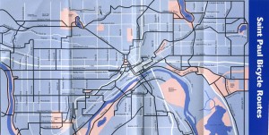
Yesterday, I posted the Chain Gang 1998 map of Minneapolis bicycle routes. The other side of this fold-up map features the equivalent for the Saint Paul side of the river. My scan accidentally cut off a wee bit of the bottom, but I assure you it’s not a cataclysmic loss.
In all seriousness, not a lot has changed. We picked up an additional bridge at I35E a few years back, which has been awesome, but most of what’s on this map remains a good option, and while there are a few streets not marked that also work, they haven’t been significantly re-engineered since 1998. Unlike the Minneapolis map, the Saint Paul map includes numerous streets without striped bike lanes.
Note that Jefferson is marked as a good bicycle route as far back as 1998. This is interesting in light of recent debate about making Jefferson a ‘bicycle boulevard’ – maps like this support my assertion that all such a move does is codify it with some parking changes and paint, but that cyclists have been using it as such for years.
To say that not much has changed is not to say that improvements haven’t occurred – see also the update to the Shepard Road path as an example. However, it’s generally been fairly easy to navigate St. Paul via streets and bicycles for some years, and arguably the arterial options haven’t needed to be changed much.


August 24, 2010 at 1:26 pm
Saint Paul’s big challenge has been traveling north-south along the Snelling axis. There are several problems with getting over 94 and especially getting over the rail yards and a secondary rail line to the north. Unfortunately this hasn’t improved much over the past decade even with the Hamline bike/foot bridge.
I don’t think Minneapolis has any similar blockages.